
Excerpts: Tinged green by age, copper sheathing from the disintegrated wooden hull of a newfound shipwreck sits deep in the Gulf of Mexico (map), where the craft sank as far back as 200 years ago. Despite clues found in surrounding artifacts—muskets, beer bottles, an anchor—the ship’s exact age, origin, and purpose remain unknown.
Hinted at by oil-exploration sonar readings in 2011, the roughly 80-foot (24-meter) ship was discovered off Texas last month during a 56-day expedition by the U.S. National Oceanic and Atmospheric Administration (NOAA) and the Bureau of Ocean Energy Management (BOEM).

Excerpts: A century and half after their deaths aboard one of history’s most famous warships, two sailors from the USS Monitor were laid to rest at sunset Friday on a hillside in Arlington National Cemetery.
In what might be the last funeral of the American Civil War, the two shipmates were buried with elaborate military honors, their flag-covered caskets carried on horse-drawn caissons as a throng of dignitaries, crew descendants and bystanders looked on.
…In 2002, more than a century after the ship sank, the almost-complete skeletons were found, one on top of the other, amid a tangle of huge guns and debris in the turret.
“I think . . . one was helping the other” in the ship’s last moments, said James P. Delgado, director of NOAA’s Maritime Heritage Program. “Seasick, hurt, whatever.”

Excerpts: In life, Coast Trader was a nondescript old coastal freighter that plied the west coast of the U.S., ferrying goods between Washington, Oregon and California. In death, however, it has grown in stature, being the second merchant vessel to be sunk during the Second World War by a submarine off the west coast of North America.
…Delgado arranged to have a remote submersible, the Hercules, dive to assess the wreck from the deck of Ballard’s Nautilus. The vessel, which works with Canadian universities, wintered in Victoria and is about to start a new season of ocean exploration down the U.S. coast.
“This is what we call a voyage of opportunity, since the Nautilus will basically drive right over the Coast Trader,” Delgado said.

Excerpts: A clipper ship built in Maine that sank off the coast of California 151 years ago has been found buried on the ocean floor just west of San Francisco.
The Noonday, built on Badger’s Island in the Piscataqua River in 1855 to haul cargo to California during the Gold Rush, was found mired in mud by an expedition of marine archaeologists. The scientists were on a five-day survey with the National Oceanic and Atmospheric Administration that ended Monday after discovering the sites of at least four wrecks, including the 1863 wreck of the Noonday.
…“Noonday is there. The sonar is very clear. But there’s just nothing sticking above the seabed,” James Delgado, NOAA’s maritime heritage director, told The Associated Press. There are no plans to excavate the site.

Excerpts: New 3-D images (bottom picture) released today by the U.S. National Oceanic and Atmospheric Administration (NOAA) show the Civil War-era gunboat U.S.SHatteras (top) in exquisite detail.
…The resolution is so good, “it’s almost photographic,” said archaeologist James Delgado, director of maritime heritage for NOAA’s Office of National Marine Sanctuaries. Delgado and his collaborators have also produced fly-through animations of the historic site and war grave.

Excerpts: ANCHOR AWAITS
Warship, privateer, or passenger ship: The identities of three early 19th-century shipwrecks resting on the seafloor in the Gulf of Mexico (map) could be any number of things. But a group of researchers have spent the past week mapping and excavating these well-preserved finds in order to find out.
…”We think all three vessels were sailing together,” said James Delgado, director of maritime heritage with the U.S. National Oceanic and Atmospheric Administration’s (NOAA) Office of Marine Sanctuaries. They were found in the same area and had the same kinds of bottles and octants, a navigational tool.

Excerpts: At the bottom of the Gulf of Mexico, far enough from both shore and surface that the water no longer carries the silt of the Mississippi, the wreck of a ship rests at a slight angle. The boat’s structure has collapsed and artifacts litter the sandy seafloor—ceramics, demijohns, old medicine bottles, and more.
…“What’s giving us a sense of the nineteenth century are the anchors, cannons, some of the bottles, and the navigational instruments,” says Delgado on the video feed. “And if the ship had been abandoned, the captain would have grabbed the instruments to navigate the small boat away. This suggests these guys did not make it.”

Excerpts: A research team has discovered a monster submarine built by the Japanese Navy during World War II, which sank off the southern coast of Oahu, Hawaii, in 1945.
Designed to ferry three seiran bombers in its massive 150-foot (46-meter) hangar, the I-400—also known as a Sen-Toku class submarine—was the first of three aircraft carrier submarines built by the Japanese for their war effort.
They were the largest submarines in existence until the construction of nuclear ballistic missile submarines in the 1960s.
…U.S.S. Alligator
This was the U.S. Navy’s first submarine, said James Delgado, director of maritime heritage for the U.S. National Oceanic and Atmospheric Administration’s (NOAA) office of National Marine Sanctuaries. Delgado was part of the research team that found the I-400.
Excerpts: After more than half a century, a mystery of military history has finally been resolved.
Researchers at the University of Hawaii and the National Oceanic and Atmospheric Administration (NOAA) have discovered a missing World War II-era Japanese mega-submarine under more than 2,300 feet of water off the southwest coast of Oahu.

Excerpts: Unusually calm weather and clear water during the waning Arctic summer has helped Canadian archaeologists get their best look yet inside their nation’s most famous shipwreck, the Franklin Expedition’s H.M.S. Erebus.
...The lost expedition’s allure “is like the appeal of the Titanic and Antarctic explorer Robert Scott,” says nautical archaeologist James Delgado, director of NOAA’s Maritime Heritage Program. “It’s an epic failure on a grand scale, where people met their fate with resolute determination.”

Excerpts: When the turret of the USS Monitor was raised from the ocean bottom, two skeletons and the tattered remnants of their uniforms were discovered in the rusted hulk of the Union Civil War ironclad, mute and nameless witnesses to the cost of war. A rubber comb was found by one of the remains, a ring was on a finger of the other.
Now, thanks to forensic reconstruction, the two have faces.
...Delgado said this much is known about them. One was between 17 and 24 years old, the other likely in his 30s. They were Caucasian, so neither was among the three African-Americans who served on the Monitor's crew, he said.
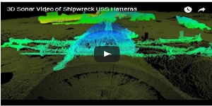
Excerpts: ...The Hatteras was sunk in a battle with the Confederate raider CSS Alabama, and was the only Union warship sunk in combat in the Gulf of Mexico during the Civil War.
“Most shipwreck survey maps are two-dimensional and based on observations made by sight, photographs or by feeling around in murky water while stretching a measuring tape,” said James Delgado, with NOAA’s Office of National Marine Sanctuaries, in the statement. “Thanks to the high-resolution sonar, we have a three-dimensional map that not only provides measurements and observations, but the ability for researchers and the public to virtually swim through the wreck’s exposed remains and even look below the surface at structure buried in loose silt.”
Excerpts: As the 100th anniversary of Titanic’s sinking approaches, a team of scientists, engineers and imaging experts have joined forces to answer one of the most haunting questions surrounding the legendary disaster: Just how did the “unsinkable” ship break apart and plunge into the icy waters of the North Atlantic on April 15, 1912?
...The team believes its cutting-edge approach represents a paradigm shift in underwater archaeology. “Speaking as an archeologist, I think it’s extremely exciting,” said James Delgado, director of maritime heritage for NOAA’s Office of National Marine Sanctuaries. “This technology and these AUVs are as much a game changer for this kind of work on the bottom as going from a landline to a Blackberry.”
Excerpts: Explorers and United States government experts have put together the first comprehensive map of the Titanic’s resting place, illuminating a square mile of inky seabed as a guide to better understanding the liner’s death throes and better preserving its remains.
...“People have the right to see, explore and learn,” said James P. Delgado, director of maritime heritage at the National Oceanic and Atmospheric Administration, which monitors the wreck. “But you want to put down guidelines like those at Gettysburg and the Acropolis, so visitors can experience it in the same way.”
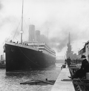
Excerpts from announcement: ...In 2010, NOAA participated in a scientific expedition to the wreck with RMS Titanic Inc., the salvor-in-possession of the wreck, Woods Hole Oceanographic Institution and the National Park Service. The expedition succeeded in completing the first high resolution detailed map and three-dimensional documentation of the entire Titanic wreck site.
James Delgado, director of NOAA’s Office of National Marine Sanctuaries Maritime Heritage Program and chief scientist on NOAA’s 2010 mission, notes, “The wreck site of Titanic is a powerful, tangible link to the events of April 15, 1912, and very much a reminder of those who built, launched, sailed on, died on, or survived the sinking. A hundred years later, their stories still have relevance and speak to us from the depths through their personal effects and the power of archaeology.”
Excerpts from the press release: (Honolulu, HI) Maritime heritage archaeologists working with NOAA’s Office of National Marine Sanctuarieshave found the nationally-significant wreckage of a famous 1800’s Nantucket whale ship, Two Brothers, on a reef off French Frigate Shoals, nearly six hundred miles northwest of Honolulu, in the remote Papahānaumokuākea Marine National Monument.
...“Discoveries like the Two Brothers serve an important role in connecting geographically separated regions and communities (New England and the Pacific), the past to the present, and provide context and better understanding human decisions that have altered the planet,” said James Delgado, director, NOAA’s Office of National Marine Sanctuaries’ Maritime Heritage Program.

Excerpts: The U-boat first spotted the Muskeget’s masts emerging from a rain squall in the distance, and despite a heavy ocean swell it moved in to attack.
...Among the 121 men on board were four civilian meteorologists from the U.S. Weather Bureau who were transmitting crucial weather reports amid World War II’s Battle of the Atlantic.
...It was quickly determined that the four men deserved Purple Hearts, said James P. Delgado, director of maritime heritage at NOAA’s Office of National Marine Sanctuaries.
“It was the right thing to do,” he said.
Excerpts: Researchers from the University of Hawaii and the National Oceanic and Atmospheric Administration announced on Friday the discovery of the USS Kailua, a ship that went missing off the coast of Oahu in 1946.
...“Seeing the ship come into view, we were all amazed at its level of preservation – and by the fact that everything was more or less in place,” said Dr. James Delgado, director of NOAA’s Maritime Heritage Program. “The identification of the wreck was easy, not only because of its unique form, but also because the Navy’s identification number of IX-71 was still painted on the bow.”
Excerpts: Researchers from the University of Hawai'i (UH) and NOAA's Office of National Marine Sanctuaries today announced the discovery of an intact "ghost ship" in 2,000 feet of water nearly 20 miles off the coast of Oahu.
...The USS Kailua wreck is considered an historic site. "We plan to nominate the wreck to the National Register of Historic Places," noted Delgado. "This unique American ship, vital in its role in keeping global telecommunications open in the first part of the 20th century, is also linked to historically significant Midway Atoll National Wildlife Refuge, now part of Papahanaumokukea Marine National Monument in the National Marine Sanctuary System. Wrecks such as this remind us of special places in the ocean, like the monument, that connect all of us to them as refuges, sanctuaries and museums beneath the sea."

Excerpts: A team of U.S. archaeologists has found the remains of a fleet of whaling ships that sank after being trapped by sea ice nearly 150 years ago.
Using "state-of-the-art sonar and sensing technology," researchers from the U.S. National Oceanographic and Atmospheric Administration located the hulls of two ships that were among 33 vessels that sank in 1871 in the Chukchi Sea off Alaska's northwest coast, near what is now the city of Wainwright.
...James Delgado, maritime heritage director for NOAA's Office of National Marine Sanctuaries, said the wrecked ships were likely pressed against a submerged sandbar less than 100 metres from shore. There, the ice tore open the hulls and smashed the ships' rigging onto the beach, while the hulls sank to the bottom.
Excerpts: ...This week’s discovery of the underwater remains of the Ituna off the coast of San Francisco by NOAA archaeologists set off a flood of nostalgia for Galvin.
“To have someone call and say ‘I’d like to talk to you about your uncle who died 90,95 years ago,’” Galvin said in his Castro Valley home, “that’s unbelievable.”
On the other end of that call was NOAA archaeologist Robert Schwemmer who along with fellow archaeologist James Delgado, is in the midst of a two-year project to catalog many of the estimated 400 ship and plane wrecks in the Gulf of Farallones National Marine Sanctuary.

Excerpts: ...The City of Chester was headed up the California coast to Eureka with 90 passengers on Aug. 22, 1888, when it was struck by the steamer Oceanic about 10 a.m.
...Delgado in May 2013 directed a crew surveying another nearby shipwreck to extend their survey to try to find the City of Chester.
After working with historic data provided by NOAA historians, the team located what appeared to be the wreck during a multibeam sonar survey. A follow-up side-scan sonar survey nine months later confirmed the target was indeed the City of Chester, "sitting upright, shrouded in mud, 216 feet deep at the edge of a small undersea shoal," NOAA officials said.
Excerpts: NOAA announced today it has found the underwater wreck of the passenger steamer City of Chester, which sank in 1888 in a collision in dense fog near where the Golden Gate Bridge stands today.
...“Discoveries like this remind us that the waters off our shores are museums that speak to powerful events, in this case not only that tragic wreck, but to a time when racism and anger were set aside by the heroism of a crew who acted in the best traditions of the sea,” said James Delgado, director of maritime heritage for NOAA’s Office of National Marine Sanctuaries, whose past work has included documenting historic wrecks in California.

Excerpts: A cold and foggy August day at sea, just off the Sonoma County coast. The ocean is gray, and so is the sky. The research vessel Fulmar is pitching and rolling in 8- to 10-foot swells.
The Fulmar is carrying a boatload of scientists and a few observers on a voyage to another time, an era when the North Coast of California was lined with tiny seaports in small coves, served by a fleet of sailing ships and steam schooners. Their cargo was redwood timber cut from the surrounding forests and shipped to San Francisco and other growing towns up and down the coast.
“They helped build California as we know it today,” said James Delgado, a National Oceanic and Atmospheric Administration historian.
Excerpts: ...“We were mystified by this wreck,” says Robert Schwemmer, NOAA’s West Coast Regional Maritime Heritage Coordinator. It wasn’t in their database of reported or known wrecks. The question haunted Schwemmer and James Delgado, NOAA’s director of maritime heritage. What was this shipwreck? What was its story?
...Schwemmer had hours of footage of the mystery tug, taken by several different cameras on ROVs. If this was the Conestoga, there should be a gun somewhere on the ship, and Schwemmer started searching through the footage, seeing if he could catch a glimpse of a gun. Finally, he saw a ghostly image that “for a second, looked like the base of a gun,” he says. He went frame by frame through the footage. There was the base. There was the gun.
He called Delgado, who was getting ready for bed, and told him to get on the computer. Schwemmer sent over a still of what he had found, and Delgado said what he was thinking: “Oh my god, Bob, we have the USS Conestoga.”

Excerpts: The USS Conestoga left the Navy yard at Mare Island, Calif., on Good Friday, 1921, bound for Pearl Harbor, with a complement of 56 sailors.
...The disappearance was one of seafaring’s enduring and tragic mysteries, NOAA said. No trace of the crew was ever found.
No one recognized that the vessel was missing until more than a month had passed and it failed to show up at Pearl Harbor, according to a report on the discovery by Delgado and NOAA colleague Robert V. Schwemmer.

Excerpts: A team of underwater archaeologists has pieced together information from declassified government documents and a shipwrecked World War II-era naval vessel to understand the secret role played by one of the most historic U.S. aircraft carriers: the USS Independence.
..."Now we not only know what shape she's in and where she lies, but also exactly what happened to the independence," said lead researcher James Delgado, a maritime archaeologist at the National Oceanic and Atmospheric Administration (NOAA).

Excerpts: Two underwater technologists from B.C. and a former Vancouver Maritime Museum executive director are playing a key role in the rediscovery and examination of an atomic-bomb test ship scuttled off the California coast.
...“It just blew me away to see the Mighty I,” said Delgado, a historian and author.
The visit was organized through Robert Ballard’s Ocean Explorations Trust and NOAA and was broadcast on Nautiluslive.org, an online teaching organization that works with Ballard’s group.

Excerpts: Federal researchers are exploring several underwater sites where ships sank while navigating in the treacherous waters west of San Francisco in the decades following the Gold Rush.
..."The Gulf of the Farallones is a graveyard of ships," said James Delgado, NOAA's maritime heritage director. "Every one of these accidents, every one of these sinkings, has its own dramatic story to tell."
...When they dropped the underwater vehicle on the third target, they found the wreckage of the SS Selja, a 380-foot cargo steamship that sank west of Point Reyes on Nov. 22, 1910.
Excerpts: ...A remotely operated vehicle spent about four hours cautiously circling the “twisted garden of steel,” as shipwreck hunter James Delgado described the remains of the 261-foot cargo freighter that sank after striking a rock south of Point Arena in September 1938.
“It was a little murky,” Delgado said of the limited underwater visibility during an interview by satellite phone Sunday aboard famed undersea explorer Robert Ballard’s high-tech research vessel Nautilus.
...Peering into the remains of the forward hold, the camera caught mud-covered cargo, including barrels, broken jars, dishes and sealed cans. The deckhouse, where the crew lived, was intact on the Wintermote’s stern, its interior pitch dark.
Excerpts from NPR transcript: In San Francisco Bay, researchers are using new technology to investigate shipwrecks. NPR's Scott Simon speaks with James Delgado, director of Maritime Heritage at NOAA, about what they've found.
...SIMON: So is this just an app you invented to find shipwrecks? What's the new technology?
DELGADO: (Laughter) No, it's a convergence, if you will, of different technologies that have been developed and getting better. They're almost off the shelf now. But in this case, we used a new software that links to sonar called Coda Octopus Echoscope. And it's a three-dimensional scanning sonar that helps us not only find things, but map them and measure them underwater.
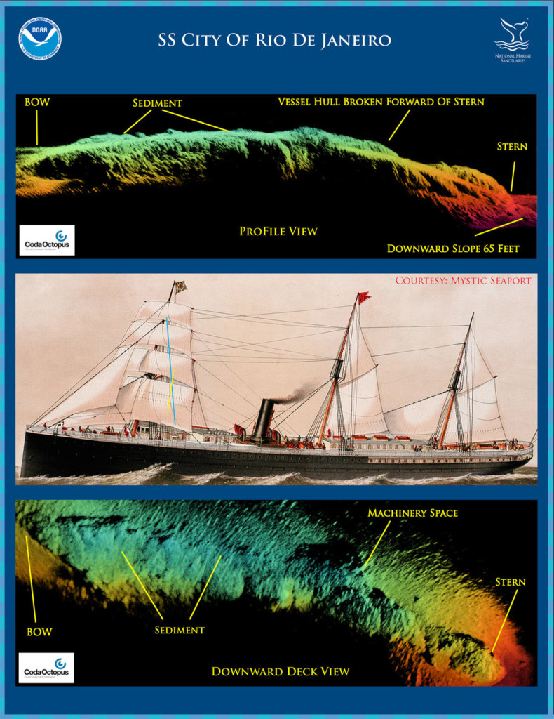
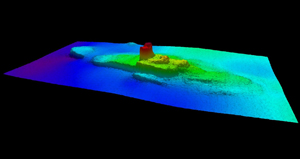
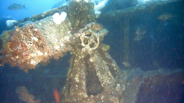
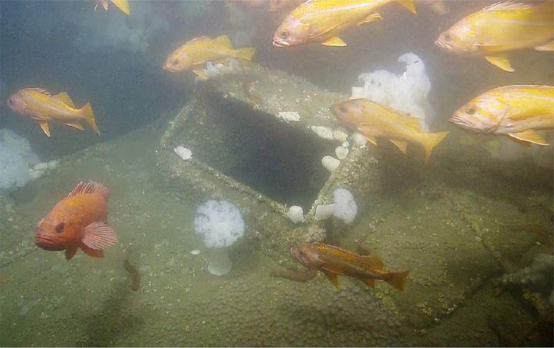
Excerpts: Scientists have created new images of the wreckage of the SS City of Rio de Janeirowhich sank into the San Francisco bay in the early morning of February 22, 1901. Only 82 of the 210 people aboard the ship survived. Most of the passengers were immigrants from Japan and China who were asleep below decks when the ship struck rocks in a heavy fog near what is now the Golden Gate Bridge. A swiftly ebbing tide pulled the City of Rio off the rocks, and within ten minutes, the ship was underwater.
..."The waters of the sanctuary and the park are one of the great undersea museums in the nation," Delgado, said in an announcement of the discovery of three wrecks in September. "These wrecks tell the powerful story of the people who helped build California and opened America to the Pacific for nearly two centuries. Finding the remains of these ships links the past to the present."
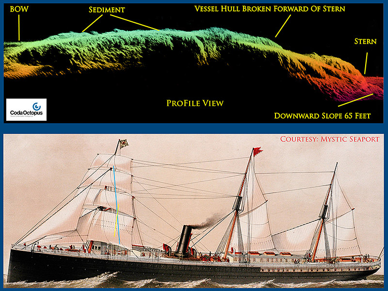
Excerpts: NOAA and its partners today released three-dimensional sonar maps and images of an immigrant steamship lost more than 100 years ago in what many consider the worst maritime disaster in San Francisco history.
On Feb. 22, 1901, in a dense morning fog, the SS City of Rio de Janeiro struck jagged rocks near the present site of the Golden Gate Bridge and sank almost immediately, killing 128 of the 210 passengers and crew aboard the ship.
...City of Rio de Janeiro was rumored to be full of silver treasure, but Delgado said accounts of a shipment of "Chinese silver" were actually bars of tin. "Today the wreck is broken and filled with mud, and it is a sealed grave in fast, dangerous waters in the main shipping lanes," he said.

Excerpts: More than 60 years after it was blown up by two atomic blasts then later sunk off the cost of California, the wreckage of the historic USS Independence has been seen for the first time.
...'After 64 years on the seafloor, Independence sits on the bottom as if ready to launch its planes,' said Mr Delgado, chief scientist on the Independence mission and maritime heritage director for NOAA's Office of National Marine Sanctuaries.
'This ship fought a long, hard war in the Pacific and after the war was subjected to two atomic blasts that ripped through the ship. It is a reminder of the industrial might and skill of the 'greatest generation' that sent not only this ship, but their loved ones to war.'

Excerpts: Steel bones of the steamship Pomona lie scattered on the rocky bottom of Fort Ross Cove, one of nearly 100 shipwrecks along the rugged Sonoma County coast, where the drowned relics once served in the region’s dominant trade route dating back to the mid-1800s.
...James Delgado, NOAA director of maritime heritage, helped draw the first map of the Pomona wreck in 1984. “You’re swimming along looking for something, (and) suddenly there’s a boiler in front of you,” said Delgado, a globe-trotting shipwreck hunter and member of the team surveying the doghole ports through Tuesday.

Excerpts: Ninety minutes before Japanese warplanes set America’s Pacific stronghold ablaze, a Navy destroyer at Pearl Harbor opened fire on an early arriving attacker.
...Delgado, the federal director of maritime heritage, is part of a team that will live-stream dives to two mini-submarine wreck sites on the ocean floor.
...“On a telepresence-enabled vessel, like Okeanos Explorer, we not only interact with other scientists, but with the public,” Delgado said. “It’s the first opportunity for the public to see these subs live.”

Excerpts: ...An estimate of the value of sunken treasure in the world begins with a guess at the number of sunken ships. James Delgado, director of the Maritime Heritage Program at the National Oceanic and Atmospheric Administration (NOAA), estimates that there are a million shipwrecks underwater now.
“Given everything that’s charted and all the rest, I would say that the majority of them remain undiscovered,” Delgado says.

Excerpt: “In terms of history, these are priceless national treasures,” says James Delgado, director of a maritime-heritage program within the National Oceanic and Atmospheric Administration. “They talk about not just ships of treasure, but vessels that really were the lifeblood of the American economy.”
When James P. Delgado became director of the Maritime Heritage Program at the U.S. National Oceanic and Atmospheric Administration (NOAA) in 2010, the agency’s Battle of the Atlantic Project was in its third year. The ambitious multiagency effort seeks to research, locate and document the many German U-boats, Allied warships and merchant marine vessels lost in the early 1940s along the mid-Atlantic coast. Delgado—a marine archaeologist, historian, museum director and author of 33 books—speaks often of his passion for the sea and for history.

Excerpts: (Honolulu, HI) Maritime heritage archaeologists working with NOAA’s Office of National Marine Sanctuaries have found the nationally-significant wreckage of a famous 1800’s Nantucket whale ship, Two Brothers, on a reef off French Frigate Shoals, nearly six hundred miles northwest of Honolulu, in the remote Papahānaumokuākea Marine National Monument.
…“Discoveries like the Two Brothers serve an important role in connecting geographically separated regions and communities (New England and the Pacific), the past to the present, and provide context and better understanding human decisions that have altered the planet,” said James Delgado, director, NOAA’s Office of National Marine Sanctuaries’ Maritime Heritage Program.

Excerpts: NOAA’s Office of National Marine Sanctuaries and Spain’s Ministry of Culture announced today the signing of a memorandum of understanding outlining a framework to jointly identify, protect, manage and preserve underwater cultural resources of mutual interest within their respective areas of responsibility.
…“The heritage spawned by Spain’s interactions with the sea and the exploration and settlement of our coasts by Spanish mariners dates back 500 years,” said James P. Delgado, Ph.D., NOAA National Marine Sanctuary Maritime Heritage Program director. “This arrangement will give us access to the incredible records in the archives and libraries of Spain.”